13km medium-hard circular hiking route of pysically demanding valley ascent to ridgeline peeks and descending via rocky boulder strewn landscape with lakes
Updated: Nov 22, 2024by: Barcelona Travel HacksViews: 580
About Andorra's Pic de Pessons Pyrenees Mountain Hiking
12km medium-hard circular hiking route from Grau Roig ski resort parking via the Circ de Pessons. The route starts with a constant uphill climb initially via ski slopes then into natural mountain landscape ascending to a series of peeks along a ridgeline route before descending via a series of lakes back to the parking area.
The principal points of interest are the mountain valleys (Coll), summits (Pic), rivers (Riu) and lakes (Estany):
Riu Dels Colells
Collada de Montmalús
Estany de Coma Estremera
Collada de Montmalús
Pic de Montmalús
Pic d'Alig
Coll de Ríbuls
Pas de Ríbuls
Portella de Pessons
Pic de Pessons
Collada de Pessons
Estany del Cap de Pessons
Estany de les Fonts
Sisè Estany
Estany del Meligar
Estany Rodó
Tercer Estany
Estany Primer
bosque dels peu dels pessons
Riu de Pessons
The route trails cover varied terrain, including forests, meadows and rocky paths. The path between the Ríbuls peaks is narrow and steep. The descent from the Collada de Pessons is made of loose stones and a steep slope. Various signage with yellow marks, GR and stone milestones indicate the trails. There are also information posts at some of the intersections. Above all this route has amazing 360 panoramic views of all the peaks in the area.
NOTE: This route is extremely physically demanding and I only recommend it for frequent experienced mountain hikers.
SAFETY TIP: I recommend Andorran routes at altitudes of over 1,700 metres between the end of June and the end of September. This route has peeks at altitudes of 2700 with the highest point of Pic de Pessons being at 2862 metres so outside of this summer window will be covered in snow and ice. The narrow ridge at the Ríbuls peaks is probably impassable in snow and at best extremely dangerous in snow with its steep drop on either side.
One of the attractions of this route is the last section between the Estanys de Pessons, consisting of eight lakes, could be a simpler route for the whole family or inexperienced hikers.
Allow 7 to 9 hours to complete this route. You can also swim in the lakes but the water is very cold.
Image Gallery for Andorra's Pic de Pessons Pyrenees Mountain Hiking
Click on any of the 36 images to open full screen gallery player
❮❯
Visiting Andorra's Pic de Pessons Pyrenees Mountain Hiking
From the Grau Roig Parking Area follow the road towards the big mountains passing multiple ski related buildings and ski lifts and keep heading along the gravel road towards the pine forest. Next to the Trattoria 3 Estanys restaurant is a wooden bridge that crosses Riu Dels Colells and leads onto an ascending forest path that forms part of the ski slope. keep pushing on through the forest along this trail paying attention to the route as it does switch ski trails.
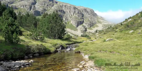
At the top of the ski area at Grandvalira you will see a lake Estany de Coma Estremera. from here the ski landscape ends and the rest of the route is in natural mountain landscape. Follow the ascending Coma Estremera lush green mountain valley trail until the end of the green section as it transitions into a rocky landscape with boulders. This uphill push is a bit draining but eventually reaches a crest called Collada de Montmalús where you will find a rusty old winch on a pole as well as amazing views down the other side of the mountain. I recommend taking a short 5 minute rest here before continuing.
The trail turns to the right onto a gradually ascending route via a mountain top plain with wild flowers that passes via the peeks of Pic de Montmalús then descending a little and moving on to the Pic d'Alig summit. on the other side of this peek there is steep rocky descent down to the most scary part of the route!
Pas de Ríbuls is a narrow footpath along a ridge where on either side of the narrow path the mountain slopes away in a rocky scree field. The Pas de Ríbuls is like a mountain tight rope between the two peeks either side of it. The path is about half a metre wide so not at all dangerous but you need to watch your footing here.
On the other side of Pas de Ríbuls to the right you will see the path leading up the rocky peak to the next summit of Pic de Ríbuls continue along this ridge top path as it ascends and descends through a small mountain top plain. You will reach a small pyramid of rocks marking the Pic dels Pessons 2862 metre mountain summit.
From here the route starts to descend along this mountain top plain towards Coll dels Pessons where at this crest the route turns to descend down a zig zagging rocky path down the mountain. Stay on the path and test your footing on any rocks to ensure that they are not loose. take care in this section of the descent.
As the path begins to level out you will see the well trodden route cross a boulder field of basket ball sized rocks so pay attention not lo loose sight of the trail. Shortly the small boulders will disperse as the route opens into a grassy mountain plain with larger boulders around the Estany del Cap de Pessons. continue through this rocky and grassy landscape following the trail on to Estany de les Fonts.
The trail continues to descend via the same rocky and grassy landscape passing Sisè Estany and Estany del Meligar and it is here that we start to see sporadic pine trees in our views. I recommend following the trail here also because around these lakes is marshland and deviating might mean slipping into some boggy ground and getting wet feet.
The descent is now reasonably shallow as the path traverses the green landscape with boulders, rocks and sporadic pine trees passing Estany Rodó, Tercer Estany and Estany Forcat before entering a steaper descending trail of denser pine trees down to Estany Primer. On the oposite side of the lake you will see Refugi del Llac de Pessons. Time permitting, you could stop here but the restaurant closes at 5pm.
The last section of this trail is via Bosc del peu dels Pessons through dense pine forest along Riu de Pessons river before intersecting with a ski trail for the final descent back to Grau Roig ski resort parking.
Hiking Vall de Incles with a dog
This route is great with a dog and does not present any difficulties. Your dog can swim a in the streams and lakes. at the top of the route there is a narrow section along a ridge but it should be fine with a dog.
During the ascent and descent in the lower foothills, the path passes via pine forests so in spring and Summer be vigilant for poisonous Pine Processionary Caterpillars.
What to take with you for Andorra's Pic de Pessons Pyrenees Mountain Hiking
This is an medium walking route in the high Pyrenees mountains of Andorra. I always do it with a small rucksack of the essentials and first aid kit. Emergency waterproof/windproof jacket is recommended.
Take 3 to 4 litres of water. You will drink a lot in the uphill ascent.
Andorra's Pic de Pessons Pyrenees Mountain Hiking Tickets
2 hour guided snow shoe excursion from the Grau Roig ski resort through the Grau Roig valley pine forests and lower hills of Pessons. Includes Snow shoe and walking stick rental.
Getting to Andorra's Pic de Pessons Pyrenees Mountain Hiking
Address: Estación de esquió de Grandvalira sector Grau Roig, Andorra. AD200
Leave Barcelona via the C58 motorway passing Sabadell and Terrasa and transition onto the C16 passing Berga. Take the toll Tunnel de Cadí (€13.93 for a car) and after passing the toll booths at the northern end there is a service station Àrea de Servei Túnel del Cadí - Porta Cerdanya. immediately after the service station is junction onto the C162 towards Puigcerdà.
Continue on the C162 as it transitions into the N260. Cross Puigcerdá via N-152 then at a roundabout take the N-152 towards Llívia. After crossing the border into France, take the N20 passing Latour-de-Carol. After Porta the N20 enters a tunnel. After exiting the tunnel take a right turn onto the N320 towards Andorra. Turn right onto the N22 and follow it to a roundabout and turn into the CG-28 which is a tunnel into Andorra that bypasses a long and winding mountain road.
Exit the tunnel in Andorra and exit at the first junction leading up to a roundabout. take the exit onto the CG-2 towards El Pas de la Casa. After 700m take a right turn onto Caraterra de Grau Roig and follow for 1.6km to the Grau Roig Parking Area.
It might be obvious to enter Andorra from the Spanish side but this hiking route is in northern Andorra near the French border so to avoid the traffic in Andorra de la Vella, enter Andorra from the French side at Pas de la Casa.
Wikiloc Trail for Andorra's Pic de Pessons Pyrenees Mountain Hiking
a0357 - Andorra's Pic de pessons Pyrenees Mountain Hiking
12km medium-hard circular hiking route of pysically demanding valley ascent to ridgeline peeks and descending via rocky boulder strewn landscape with lakes