Pyrenees hiking via Serra De Montgrony from Toses to Planoles
13 Km walk from Toses to Planoles via Serra de Montgrony mountain ridgeline giving spectacular 360 panoramic views descending and climbing to each peak
Updated: Nov 18, 2024by: Barcelona Travel HacksViews: 2k
About Toses to Planoles via Serra De Montgrony
Serra de Montgrony, also known as Sierra de Montgrony, is a mountain ridgeline in the Parc Natural del Cadí Moixeró bordering the Ripollés and Berguedà counties of the Spanish Catalan Pyrenees mountains. The Sierra de Montgrony runs from the towns of Ribes de Freser, Toses, Planoles and on to Alp via the La Molina Ski zone covering an area of 35.12 Square kilometres.
This 13km MEDIUM-HARD walking route starts at Renfe Toses Railway station on the R3 Rodalies line and terminates at Planoles Renfe one stop nearer to Barcelona along the same R3 roadalies railway line. Along the route you will find enchanting oak, beech and pine forests, mountain plains and pastures, high peeks with panoramic views of the Pyrenees mountains and La molina ski resort plus mountain streams and rivers.
The route passes via these summit viewpoints: Serrat de Paravent, hammer Stone monument Pedra picada, La Emperadora, Costa Pubilla, Tossal Meians and Tossal Meians bunker. A MEDIUM level of fitness is required. Also sturdy and grippy hiking boots are also required as the path down off the mountain is steep and in some places slippery.
The name Mogrony derives from the latin word Groyn meaning a pig or hog's snout, probably because of the local cuisine of pigs snout stew. The prefix Mont meaning mountain.
The route is ideal for hikers and outdoor enthusiasts that want a route that is not well known and overcrowded with fellow hikers. The route will give you a true feeling of remoteness to enjoy the open air. Equally when doing the route in winter, it is an ideal location for Pyrenees snow shoe hiking and hiking with crampons.
Image Gallery for Toses to Planoles via Serra De Montgrony
Click on any of the 68 images to open full screen gallery player
❮❯
Visiting Toses to Planoles via Serra De Montgrony
From the train station follow the road (GIV-4016) over the bridge that crosses the tracks at the western end of the platform and immediately after crossing over the tracks take a hard right into a paved country lane following it for a 100 metres where behind a ruined building you will see a foot path leading up into a forest.
Along this forested trail are several viewpoints overlooking the mountain village of Toses and after crossing a small stream take the right fork in the path continuing up the mountain. Take another right fork and ascend through the mountain grazing land taking a left turn onto a gravel road. Follow the gravel road for 500m and take the right fork continuing up through Pla de Querol mountain plain.
In the top corner of the plain you will find a yellow route marker consisting of small logs in the V of tree branches. Take the ascending path through the Costa Borda pine forest until it emerges in a wide mountain top plain. You are now at Cap dels plans del Ginebrar (1901m). This mountain plain forms part of the Serra de Montgrony peeks and the path now follows an ascending and descending path through a series of summits.
Turn left and head towards the first summit of Serrat del Paravement (1911m) and continue down to Collet de les Fontetes de castellar (1879m). Keep following this trail along the top of the mountains through a small pine forest to another plain to Pedra Picada summit. here you will find a summit marker on a metal pole consisting of a set of hands holding a sledgehammer and hitting a rock. Behind the summit marker is a rock semi circle viewpoint from where you can see Pedraforca mountain.
From the Pedra Picada summit follow the trail descending parallel to the wire fence to a crossroads at Coll de Remoló. Keep parallel to the wire fence ascending a rocky path to the next summit called Cim de l'Emperadora (1962m). Descend the other side of this summit until reaching a wire fence and parallel this fence through Coll de la Bona onto the next summit at Bunquer del Roc dels Llamps. Here you will find a concrete bunker of WWII era, that I assume was built to monitor crossings from France via the mountains.
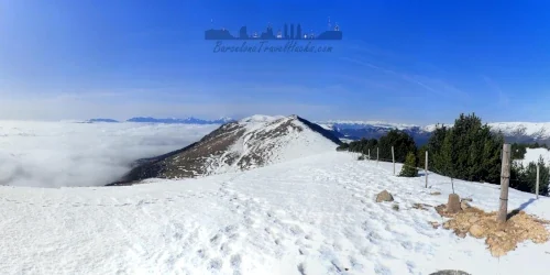
Continuing on the same trail upwards leads to the Tossal Meians summit (2051m). continue following the trail up to the final summit at Costa Pubilla (Cim de Plá de Pujals) (2056m). Follow the path parallel to the fence as it bears left and descends down to Coll de Coma Ermada. Keep an eye out for a gate in the fence because you will need to cross through the fence here to start the descent to Planoles.
Cross the mountain plain and look out for a descending path on the left heading in to the pine forest. after exiting the pine forest you will find a muddy area around a cattle drinking tub at Fortí de la Font Negra (1786m). Beyond this farm area, turn right and follow the fence through a small summit called Coll Roig. Here you will find a signpost pointing to Campelles and Planolles. Take the path towards Planolles. Keep an eye out for yellow markers because the trail is a bit hidden at this junction.
The trail is a descending forested footpath and may have a few fallen trees that you need to duck under along the path. At Coll Garroter you will find a viewpoint overlooking the foothills and grazing fields. Continue following this trail down making sure you follow the yellow route markers. This trail emerges from the forest onto a gravel road. almost immediately opposite is another descending footpath through the forest. make sure you do not miss this path because it is not signposted.
The final leg of the route descends through a forest parallel to a mountain stream and emerges on to a trail next to El Rigat river. Turn left and follow the river path to a fording point behind Alberg Planoles Xanascat hostel. Cross the river either jumping from rock to rock or wading in the 10cm deep water. On the other side of the river follow the path to Camp de futbol de Planoles and bear right taking the gravel track. turn left onto the GIV-4015 road and after 20 or so metres at the recycling bins you will find a footpath leading up to the station. Cross the railway tracks at the end of the platform using the level crossing footpath ensuring to look both ways before stepping out onto the tracks.
Where to Eat
Toses: At the Renfe/Adif station building you will find that it has been converted into a a small hostel (Hostal Estació Toses) with restaurant bar on the ground floor accessed from the street side of the building.
Planoles: next to the eastern end of the station platform is La Cantina de Planoles, a small restaurant.
TIME: Allow 7-9 hours to complete the route. To complete this route as a one day trip from Barcelona I recommend getting the first R3 train leaving Barcelona around 6:20am to allow contingency time. 5 minutes walk from Planoles train station you will find the Planoles Xanascat Hostel.
WEATHER: In the summer the route will be green mountain pastures with wild flowers. In Winter, normally between January and March, there is Snow in the high (2000m) Pyrenees summits.
Hiking the Serra De Montgrony from Toses to Planoles with a Dog
This route is fine and will present no challenges or difficulties for a dog. Take care when traversing the paths through the pine forest of completing the route in spring or summer because there may be poisonous Processionary Caterpillars.
What to take with you for Toses to Planoles via Serra De Montgrony
I pack for wind and rain when doing this hike because it is in the high Pyrenees mountains.
I recommend 2-3 litres of water because there is nowhere to top up water bottles along the route.
If doing this as a winter hike, I recommend crampons for added traction on any snow or ice.
Toses to Planoles via Serra De Montgrony Summary of Prices
Getting to Toses to Planoles via Serra De Montgrony
Address: Estacio de RENFE, Toses. 17536
Take the Renfe Rodalies, R3 line, Barcelona to Pyrenees train (Pigcerda or Latour-de-Carol) getting off at Toses station and returning from Planoles station on the same line.
The R3 Rodalies line is the only train line from Barcelona that will take you to the foot of the Pyrenees mountains which is why the best train accessible hiking routes can be found starting and ending from many stations along this train line.