Vall d’Incles Andorra Hiking – Glacial Lakes & Pyrenees Views
One of Andorra’s most beautiful hikes: a 15km circular route through Vall d’Incles with glacial lakes, waterfalls and sweeping Pyrenees mountain scenery
Views:
1.5k
About Andorra Vall de Incles Hiking
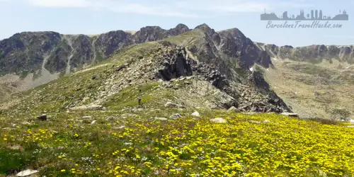
The first steps into Vall d’Incles feel like entering a hidden world carved out by ice and time. The valley opens slowly, framed by steep forested slopes, the sound of water rushing somewhere out of sight, and the scent of pine drifting on the cool mountain air. It’s one of those rare Pyrenean landscapes that feels untouched — a place where the trail rises gently at first, then suddenly lifts you into a high‑mountain world of glacial lakes, waterfalls and wide grassy plains.
This 15‑kilometre circular hike is considered one of the most beautiful routes in Andorra. The climb leads you from quiet meadows into a vast alpine plateau dotted with lakes such as Estany de Querol, Lagunas Les Salamandres, Estany de Cabana Sorda and Estany d’Anrodat — each one different in colour, shape and mood. Horses graze freely, waterfalls tumble down from the French border peaks, and the valley feels alive with the movement of water, wind and wildlife.
Between the towns of El Tarter and Canillo, a tight hairpin on the CG‑2 hides the entrance to the Carretera de Vall d’Incles. This narrow country lane leads into the valley and marks both the start and end of the circular route. From here, the trail climbs through forest and rocky slopes before opening onto the high plain. The return follows the Riu de Manegar riverside path, creating a loop that feels varied and constantly changing.
Along the way you’ll encounter two waterfalls, four lakes perfect for swimming, the 20‑bed Estany de Cabana Sorda mountain hut, and sweeping viewpoints across meadows filled with wildflowers. Free‑roaming horses, cows and sheep often wander through the valley, adding to the sense of untouched mountain life.
The final two kilometres follow the Carretera de Vall d’Incles gently downhill, passing traditional stone houses, restaurants and bars before returning to the parking area. It’s a route that rewards every step with something new.
I recommend combining this hike with my Pic de Pessons route to create a full weekend of high‑mountain hiking in Andorra.
Image Gallery For Andorra Vall de Incles Hiking
Click on any of the 60 images to open full screen gallery player. Note that viewing images is subject to our Fair Use Policy.
Visiting Andorra Vall de Incles
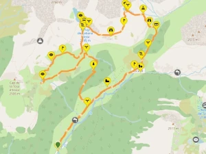
From the parking area at the entrance to Vall d’Incles, follow the narrow road for around 1.5 kilometres as it gently climbs into the valley. On the left you’ll pass a small picnic area and a path leading up through a mountain meadow towards the forest. Take this path and continue ascending until you reach the Riu de Els Comellassos, a natural spring where cold, clear water flows straight from the rock.
The climb continues through dense Pinosa forest, gaining height steadily until the trees thin and the trail emerges onto a wide mountain plain. Look for a path branching left, heading west across the open meadows towards Estany de Querol and the Basses de les Salamandres. These lakes lie about 30 minutes away across gently rolling terrain. Estany de Querol is my favourite for swimming — the water is crystal clear, icy, and incredibly refreshing.
After visiting these lakes, take a north‑easterly path across the grassy hills to meet a trail running parallel to the Riu de Cabana Sorda. The route crosses the river at a small waterfall and continues across a rocky plateau towards the Estany de Cabana Sorda mountain hut. Behind the hut lies the lake itself, framed by a dramatic horseshoe of peaks that form the border with France.
Estany de Cabana Sorda is the most spectacular lake on the route. It’s partially dammed, creating a deep, calm pool of turquoise water. A small island forms a natural “beach” where you can walk into the lake. If you swim out from this point, you’ll find — just beyond neck‑deep water — a large submerged boulder that makes a perfect mid‑swim resting spot. The water is so clear you can see it from the surface. The surrounding meadow is an ideal place to stretch out with lunch or a snack.
When you’re ready to continue, follow the westerly trail behind the hut. It crosses open meadows and a rocky ledge with sweeping views down into Vall d’Incles before zig‑zagging steeply to the final lake, Estany d’Anrodat. The water here is noticeably warmer than the previous lakes, making it a great spot for a last swim.
From Estany d’Anrodat, the path descends through a rugged river valley. In the afternoons, a unique weather phenomenon often occurs: clouds spill over the high ridge and drift slowly down the valley, creating an atmospheric curtain of mist that’s fascinating to watch from above.
The trail eventually crosses a field of jagged scree before flattening into a meadow beside the Riu de Manegar. Cross the river via a small wooden footbridge hidden among the trees beside a swampy pond, then follow the path down the valley. As you approach the road near Restaurant l’Ovella Negra, you’ll see a waterfall on the right where the river drops over a rocky ledge.
The mountain path ends at the Carretera de Vall d’Incles. From here, turn right to reach the restaurant or continue straight along the road back to the parking area. The best time to hike this route is from late June to late September, though conditions sometimes allow a season stretching from May to October. Outside this window, expect ice, rain, and winter snow.
Hiking Vall de Incles with a dog
This route is excellent to do with a dog and presents no technical difficulties for a fit, healthy animal. Much of the trail runs through open meadows, rocky paths and gentle forest sections, and your dog can cool off in the streams and lakes along the way.
Some parts of the lower valley follow the rural road, so you may need to use a leash depending on traffic and how busy the area is. The lakes and rivers are perfect for swimming, and most dogs love the chance to splash around after the climb.
During spring and summer, be vigilant in the pine forests on the ascent and descent. This is the season when Pine Processionary Caterpillars appear — they are highly poisonous to dogs, so keep an eye on the ground and avoid letting your dog sniff or investigate anything that looks like a caterpillar line or nest.
I have awarded this route five stars for he month of September in my dog hiking calendar.
Where to Eat
This is a route I’ve hiked twice, and there are a few great places nearby to refuel before or after the hike. Vall d’Incles has a surprisingly good food scene for such a quiet valley, ranging from simple mountain cafés to cosy restaurants serving hearty Andorran and French‑Catalan dishes.
- Bar Restaurant La Cabineta: A relaxed roadside café ideal for a pre‑hike breakfast baguette and coffee. Location
- Espai Gastronomic Art_Etxe_: A small, characterful bar‑restaurant on the road back to the parking area. They serve artisan beers, pizzas, and more refined dishes — perfect for a relaxed post‑hike meal. Location
- Tradició Grill: A long‑time favourite of mine from when I worked in Andorra for six months. Expect grilled meats, French‑Catalan classics and generous portions. The onion soup here is exceptional — deeply caramelised and full of flavour. Location
What to take with you for Andorra Vall de Incles Hiking
This is a medium‑difficulty mountain route in the high Pyrenees, so I always hike it with a small rucksack carrying the essentials. Weather can change quickly at altitude, and even on warm days the wind can be sharp, so an emergency waterproof or windproof jacket is highly recommended.
Carry at least 2 to 3 litres of water, especially in summer. The climb is steady and exposed in places, and there are long stretches without shade. Standard mountain gear — sturdy footwear, sun protection, snacks, and a basic first‑aid kit — will make the day far more comfortable.
Andorra Vall de Incles Hiking Summary of Prices
Train/Bus Fare
Entry Ticket
Additional Information
Train/Bus Fare
Entry Ticket
Additional Information
Adult
€ 35.00
FREE
Child
€ 35.00
FREE
Notes
toll Tunel de Cadí (€13.93 for a car)
Getting to Andorra Vall de Incles Hiking
Address: Caraterra de Vall d'Incles, Canillo, Andorra, AD100
Leave Barcelona on the C‑58 motorway, passing Sabadell and Terrassa before joining the C‑16 toward Berga. Continue north through the Pre‑Pyrenees until you reach the Túnel del Cadí (toll: €14.56 for a car). Once you exit on the northern side, you’ll find the Àrea de Servei Túnel del Cadí – Porta Cerdanya service station — a convenient stop for a break or a quick snack.
Immediately after the service area, take the junction for the C‑162 toward Puigcerdà. Cross Puigcerdà via the N‑152, then at the roundabout follow signs for Llívia. After crossing the border into France, continue on the N20 past Latour‑de‑Carol. Beyond Porta, the N20 enters a tunnel; once you exit, turn right onto the N320 toward Andorra. A second right turn onto the N22 leads you to a roundabout where you can join the CG‑28 — a tunnel that brings you into Andorra while avoiding the long, winding mountain road.
After emerging in Andorra, continue along the CG‑2 until you reach the town of Soldeu. As the highway curves through a tight hairpin, look for a narrow country lane branching off at the apex: the Carretera d’Vall de Incles. Take this road and you’ll reach the parking area about 100 metres further up.
Although entering Andorra from the Spanish side might seem the obvious choice, this route sits in the far north of the country near the French border. To avoid heavy traffic around Andorra la Vella, it’s far quicker and smoother to enter from the French side at Pas de la Casa.
Wikiloc Trail for Andorra Vall de Incles Hike
Please sign in with Google to view the Wikiloc Route map.
Sign in with GoogleWeather for Andorra Vall de Incles
Where to stay near Andorra Vall de Incles Trailhead
The village of Soldeu sits right next to the Vall d’Incles trailhead and offers a wide range of hotels, chalets and mountain lodges. It’s the most convenient base for this hike, with options that suit everything from simple overnight stays to spa‑level comfort. Below are places I recommend for easy access to the valley and a comfortable night’s rest.
- Borda Martí: A cosy two‑bedroom mountain chalet — perfect if you want a peaceful, private stay with traditional Andorran charm.
- L’Ovella Negra: A beautiful mountain lodge located right at the start of the trailhead. Ideal for early starts and a quiet, scenic setting.
- Hotel Galanthus & Spa: A modern hotel with a swimming pool, Turkish baths, sauna, restaurant and Wi‑Fi — great if you want comfort and wellness after a long hike.
- Hotel Piolets Soldeu Centre by Nexta: A comfortable hotel with a swimming pool and Wi‑Fi, located close to shops and restaurants in Soldeu.