Alta Garrotxa – Sadernes & Sant Aniol Waterfalls Hiking & Swimming
15 km circular route from Sadernes to the natural pools and waterfalls of Sant Aniol d’Aguja, with watermill ruins, stone farmhouses and cliff viewpoints
Views:
2k
About Alta Garrotxa Sadurnes waterfalls
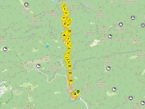
Sadurnes is a tiny hamlet in the Alta Garrotxa Natural Park (Parc Natural de l’Alta Garrotxa) and the starting point of one of Catalonia’s most spectacular summer hiking and swimming routes. This 15–16 km circular trail follows the Sant Aniol d’Aguja river valley, passing natural pools, deep gorges, watermill ruins, medieval chapels and dramatic limestone cliffs.
The Alta Garrotxa range stretches to the French border and covers 153 km² of rugged, sparsely populated mountains. Its isolation, steep ravines and mixed Mediterranean forest have created a refuge for wildlife and preserved a landscape that feels untouched. Today, the area is known for outdoor activities including hiking, canyoning, swimming and climbing.
This route is especially famous for its crystal‑clear natural pools and deep waterfall basins, making it one of the best summer swimming hikes in Catalonia. The trail crosses terrain shaped by silicic and calcareous rock, scree slopes and narrow river canyons, with vegetation ranging from lowland oak groves to riparian forest. The path follows the river upstream to the Salt de Brull waterfall, located just 4 km from the French border.
The flow of the Sant Aniol river varies throughout the year, often disappearing underground where it infiltrates the limestone bedrock. For the best combination of water levels and warm temperatures, early summer is ideal.
Note: Access to Sadurnes is regulated to protect the natural environment. A parking permit is required during the high season.
Allow 6–8 hours to complete the full circular route with time for swimming and photo stops.
Image Gallery For Alta Garrotxa Sadurnes waterfalls
Click on any of the 53 images to open full screen gallery player. Note that viewing images is subject to our Fair Use Policy.
Visiting Sadurnes – Sant Aniol d’Aguja Waterfalls, Natural Pools & Cliff Paths
From the Sadurnes parking area, walk past the Hostal de Sadernes and continue along the paved lane. Follow the road past the Església de Santa Cecília de Sadernes and through the second parking area, joining the Camí de Sant Aniol as it runs beside the Sant Aniol river.
After 1 km, the road crosses the river via the Norman‑arch stone bridge of Pont del Pas dels Aures. It’s common to see the riverbed dry here — the water is held upstream by a weir. Continue for another 700 m to the iron bridge, Pont de Ferro, and then a further 400 m to a small parking area and the second Norman‑arch bridge, Pont de Valentí, where you cross the river again.
On the far side stands a restored stone farmhouse now operating as Easy Day Hostel / Hostal de Ca la Bruta, offering nature‑based retreats. From here, take the forest path parallel to the river for 1.5 km until you reach the Molí de Riu watermill ruins. The trail dips to a natural fording point where you cross to the opposite bank.
After 500 m, the valley opens into the turquoise pool of El Gomarell, created by a small weir. This is the first excellent spot to cool your feet or take a dip. Cross the top of the weir to the opposite bank. The next kilometre is a steep ascent, climbing from 356 m to 552 m via rocky switchbacks. Along the way, you’ll enjoy panoramic views of the limestone cliffs known as the Cingles de Guitarriu, and cross two scree slopes with dramatic drops into the valley.
After a flatter 1 km traverse, the path descends back towards the river. Take the left‑hand fork, passing the ruined farmhouse of Cal Sastre. When you reach the Ermita de Sant Aniol d’Aguja, turn left to reach Gorg del Fosc — a deep, shaded pool ideal for swimming. Continue 500 m upstream to the spectacular Salt de Brull waterfall, one of the best natural pools in Alta Garrotxa and a popular canyoning spot.
This is the turnaround point. Return to the Ermita de Sant Aniol d’Aguja, but do not take the steep mountain path you arrived on. Facing the chapel, take the small path to the left beside the Refugi Sant Aniol d’Aguja. It descends to a wooden footbridge crossing the river. Turn right and follow the riverside trail for 1 km.
Cross the river at the natural ford and continue along the forest path until it emerges onto a narrow cliff‑side trail beside the river. This leads to Gorg del Citró, one of the most beautiful swimming spots in the region. The water here is a dazzling clear blue, and you can swim a short way up the narrow canyon. Continue along the path as it crosses the river again via a wooden footbridge.
Follow the river for another kilometre, crossing several shallow fords, until you return to El Gomarell and the weir you crossed earlier. Retrace your steps to the Molí de Riu ruins, then take the left fork onto the riverside path passing the La Farga watermill ruins. Cross the river once more and continue for about 1 km to reach Pont de Valentí and the Easy Day Hostel. From here, follow the road back to Sadurnes.
Just before reaching the Església de Santa Cecília de Sadernes, you can stop at the Hostal de Sadurnes garden for a cold drink and snacks — a perfect end to a long day of hiking and swimming.
Sadurnes waterfalls hiking & swimming with a dog
This route is generally suitable for dogs and does not present major technical difficulties. Most of the trail follows forest paths, riverbanks, and shaded woodland, which makes it comfortable for dogs in warm weather.
There is one short section along the top of the river canyon where the path crosses boulders. You may need to assist your dog here, especially if they are small or not used to scrambling.
Because the route follows the Sant Aniol river for long stretches, dogs have frequent access to clean running water, so you do not need to carry extra water specifically for them. However, keep an eye on water levels in late summer when some sections of the river run dry.
At the beginning of the hike, the paved lane between Sadurnes and the river has occasional vehicle traffic, so it’s sensible to keep your dog on a leash until you reach the forested section.
The trail passes through mixed woodland with relatively few pine trees, but in spring and early summer you should still stay alert for pine processionary caterpillars, which can be dangerous to dogs if encountered.
What to take with you for Alta Garrotxa Sadurnes waterfalls Hiking
This is a medium‑difficulty mountain route in the Alta Garrotxa, with long stretches of forest trail, rocky ascents and frequent river crossings. A small rucksack with the essentials is all you need, but make sure you’re prepared for heat, water, and uneven terrain.
Carry 2–3 litres of water. Even though the route follows the Sant Aniol river, some sections run dry in late summer, so you cannot rely on the river for drinking water.
Wear sturdy hiking footwear. The trail includes rocky switchbacks, scree slopes, boulder sections and slippery river fords. Lightweight running shoes are not ideal for this terrain.
Bring swimwear and a small microfibre towel if you plan to enjoy the natural pools at El Gomarell, Gorg del Fosc or Salt de Brull. Water shoes can be useful for entering the pools or crossing shallow fords.
A lightweight waterproof or windproof jacket is recommended. Weather in the Alta Garrotxa can change quickly, especially in the shaded ravines.
If hiking with a dog, you generally won’t need to carry extra water for them thanks to the river access, but stay alert for pine processionary caterpillars in spring and early summer.
Tickets for all inclusive Guided Hiking at Sadurnes
Powered by
GetYourGuide
Alta Garrotxa Sadurnes waterfalls Summary of Prices
Train/Bus Fare
Entry Ticket
Additional Information
Train/Bus Fare
Entry Ticket
Additional Information
Adult
€ 30.00
FREE
Child
€ 30.00
FREE
Notes
Hike is free. Parking costs €5.56 per day with a limit of 100 parking spots.
Getting to Sadurnes
Address: Parking Sadernes, Sadurnes, Girona, 17853
Sadurnes is only reachable by car. Access to the area is regulated during the high season, so make sure you have a valid parking permit before travelling.
From Barcelona, take the AP‑7 towards Girona and exit at junction 5 onto the C‑66 towards Banyoles. Continue past Banyoles to Besalú, then join the A‑26 towards Olot. At km 75, take the exit for the GIV‑5233 towards Montagut, and from there follow the GIV‑5231 to Sadurnes. Allow around 2 hours of driving time.
Alternatively, take the C‑17 to Vic and continue on the C‑37 and C‑152 towards Olot. From Olot, join the A‑26 towards Besalú and exit at km 72 onto the GIV‑5233, following signs to Montagut and then Sadurnes.
Wikiloc Trail for Alta Garrotxa Sadurnes waterfalls
Please sign in with Google to view the Wikiloc Route map.
Sign in with Google