Rivers of Aragon I - Alquézar & River Vero hike
Discover spectacular Alquézar village & complete a 13km circular hiking route via River Vero walkways in Sierra y Cañones de Guara Natural Park
About Alquézar & River Vero hike
This day activity is to explore the village of Alquézar and hike the famous Pasarelas del Vero 13km circular hiking route along the River Vero.
The Arabic name al-Qasr from which the modern Spanish Alquézar derives means a castle, palace, or fortress. The town is named because it was founded around the hilltop Arabic fortress.
It was one of the main fortresses of the Barbitania, protecting access to the Barbastro region. According to Muslim chroniclers, it first belonged to the Banu Jalaf and would be conquered in 893 by Ismail ibn Muza, of the Banu Qasi de Zaragoza, and later taken by al-Tawil. In 938, Abd al-Rahman III named his son Yahia governor of Barbastro and Alquézar. Jalaf ibn Rasid built the fortress at the beginning of the 9th century as a defensive position against the Christian Pyrenean resistance who were reconquering Southern Europe from the Muslims.
Around 1067 it was conquered by the king of Aragon, Sancho Ramírez (son of Ramiro I) and became a Christian fortress Castrum Alqueçaris, to defend against the Muslims, becoming a key point for later stages of the Reconquest. The fortress was equipped with military garrisons assisted by an Augustinian community. In 1099, the church of Santa María was consecrated as a royal chapel.
As the process of the Reconquest advances towards the lowlands of Barbastro and Huesca, Alquézar loses importance as a strategic military fortress and becomes a religious institution and commercial centre of the region, known as the Alquezarense Priory.
The increase in population in the 13th century creates a need to expand the village outside of the castle walls into what is called Burgo Nuovo Alquezaris, leaving the castle practically uninhabited, occupied only by some religious orders.
The town has a medieval appearance that has changed very little since the 13th Century. The layout of the streets is how it was with a winding alleys and streets with small squares where they join. The layout is designed to protect the houses from the sun and wind. It is a typically Muslim layout, with narrow and high streets and can often be found in the older mountain towns. Adapted to the topography with the houses crowded on the hillside.
The village had a defensive design being enclosed, perhaps walled (although no historical evidence of a medieval wall has been found). Access to the village was via three portals, two of which are preserved: the main one, Gothic (13th century), and the other in the lower part of the town. They had doors that were closed at a certain time, not allowing access to the interior of the town.
The paving of the streets was much more rustic than the current one being made of thick stone slabs laid into into the soil, without any type of mortar. The streets had a drainage system, with a slope towards the centre, a channel through which the water would flow.
The population of Alquézar was Christian, but the Mudejars (Muslims in Christian territory) roamed in the region, being the original builders of the majority of the houses. Of the current houses, the oldest date back to the 14th and 15th centuries. Alquézar lived an era of splendour in the 16th century.
The houses integrate perfectly with the surroundings through the use of native materials, such as stone (especially for corners, plinths, window frames and doors), brick, clay bricks. The Mudejar builders introduced the brick technique, more practical than stone, almost of equal resistance and, above all, better known to them. The good use of brick can be seen above all in the upper galleries of arches and in the eaves.
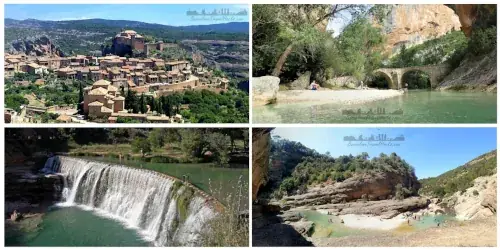
This walking route along the Vero River includes a scenic route through the historic village of Alquézar
Image Gallery For Alquézar & River Vero hike
Click on any of the 62 images to open full screen gallery player. Note that viewing images is subject to our Fair Use Policy.
Visiting Alquézar & River Vero hike
This pleasant and gentle route route starts at Alquézar Parking and follows the road north passing Mirador Sonrisa al Viento which is a viewpoint over the village. Take Calle Triador down into Barrio Arrabal where you will find a square with terrace bars. This is a great place to have breakfast because the terrace offers views onto Alquézar village and Iglesia parroquial de San Miguel Arcángel Church.
After breakfast follow the road into town looking out for Calle Medio on the right which passes under a medieval house into a pedestrian cobbled street through the town. Take the left fork into Calle Pedro Arnal Cavero passing Ermita de Nuestra Señora de las Nieves, a small chapel on the right.
At the end of Calle Pedro Arnal Cavero turn left into Calle Dragones and follow to Plaza de Rafael Ayerbe. This is a beautiful medieval village square. continue straight through the square to a building where you can pay the €5 fee to complete the Pasarelas del Vero route. The fee is to rent a hardhat for one day and also to maintain the walkways along the route. It is obligatory to take a hard hat and the guard at the start of the route will ensure you have one, have paid the fee and are wearing the hard hat. The hard hat is a safety precaution for the walkways on the side of the canyon. the rest of the route the hard hat is not necessary and can be carried in the rucksack so leave space for it to not have to carry it in your hands the whole route.
Tickets for the Pasarelas del Vero route can be booked in advance via the button below. I recommend this in the summer because the route has a limit on the number of people that can enter.
You are now ready and equipped with a hard hat and entry ticket for the Pasarelas del Vero route so return back to Plaza de Rafael Ayerbe and turn right where you will see the entrance to the route with the guard ready to inspect your ticket and hardhat. You may have to wait here 5 minutes because the guard ensures spacing of visitors.
You will soon come across the first of the small the wooden bridges, slotted between the Castibián crag to the left, and the walls of the castle on the right. A total of seven stretches of footbridge make up the descent to the River Vero. As you venture deeper, the splendour of the Barranco de la Payuala, characterised by its many small caves and a vegetation adapted to the damp and fresh conditions of the gorge.
At the bottom you reach the River Vero. follow the river bank path right about 100 metres and you will find an ox bow bend in the river and Picamartillo cave. This is an incredible natural beauty spot, one of many along this route.
From Cueva Picamartillo follow the river back the way you came and you will see some metal walkways on the right wall of the canyon. At this point a hard hat is recommended. take the walkways down the river canyon.
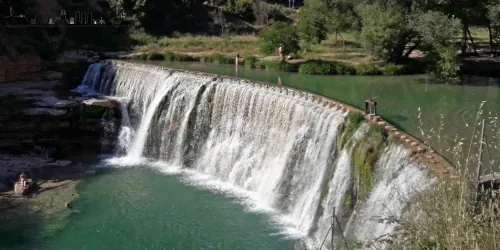
The footpath follows the river downstream by means of spectacular metal walkways attached to the rock of the wall. You will soon come across an old dam and waterfall about 50 metres beyond is a rock path down to the pool where some people like to swim. Once finished swimming continue along the metal walkways enjoying the view of the river canyon.
After following another stretch of metal walkway, you will reach the ancient hydroelectric station of Alquézar. Here also is pool of deep turquoise water that is an irresistible spot for a rest and a dip in warmer weather.
From this point the path leaves the side of the river and follows a path parallel to the river and once again goes via metal walkways in the canyon. Follow this long metal walkway and river side path until Mirador de Vero. This is a metal platform suspended partially over the side of a cliff and gives excellent views of the landscape.
Follow the path inland passing Molino d'Arriba, an abandoned stone building that was a water mill before getting to Puente de Fuendebañoso de Asque. This stone bridge Crosses the river and behind the bridge is another good spot to bathe. For the next third of the route is olive groves and will not be by the river so make sure you have enough water for the arid section.
Follow the path to the right of the river upwards through dry arid shrubland. Along the way there are several natural viewpoint that give views of Alquézar. Follow this path called Camino de Puente de Fuendebañoso and continue along as it transitions into a rural farm track through olive groves. This path will take you to the village of Asque.
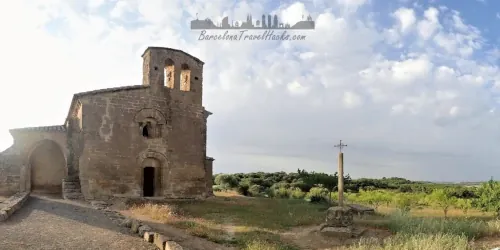
When you get to Asque the first thing you will see is the Iglesia de Santa Columba de Asque dating from 1885. The village of Asque has about 10 houses and a water fountain in the square. However, when I visited Asque the fountain and Bar Centro social were both closed so there was no drinking water available in this village.
Leave Asque via the Camí a Asque road and follow it up till the first crossroads where you can take a left turn into a rural farm track. follow the track onto the Cami de Puente de Villacantal which snakes its way through the mountains until Barranco de Lumos. This as another gorge that follows a mountain stream back down the the River Vero.
At the river Vero the first thing that greets you is a magnificent stone bridge, Puente de Villacantal, crossing the river. Behind the bridge is a natural stone beach and a great place to take a pause and swim in the river's natural pools. As you look back at the bridge from the water the views of the canyon are spectacular.
Once recharged, cross the river via the bridge and continue along the canyon top path as it gently ascends back to Alquézar. Along this path are wild mountain flowers and several natural viewpoints of Alquézar village.
When you get to the village follow the route back to the town hall nearPlaza de Rafael Ayerbe and return your hardhat. From here make your way back to the parking through the village, stopping off in Barrio Arrabal for some light tapas.
Hiking the Alquézar Pasarelas del Vero with a dog
This route is great with a dog. However, be aware that there are sections of about 50 to 150m that are along metal mesh walkways along the canyon that a dog cannot walk on. When I did this route with a dog I carried her across the walkways but it was not an issue because she weighs 7kg. This route is not viable with a large dog that you cannot carry.
The foliage is shrubland and some forested sections so there is a small chance of coming across poisonous Pine Processionary Caterpillars in the spring and summer so I recommend vigilance around pine trees.
What to take with you for Alquézar & River Vero hike
I wear the running shorts and wet shoes to complete the river section of this route. I walk the mountain section along the top of the canyon in hiking shoes. Valuables such as phone, car keys, wallet and dry clothes go in my dry bag inside my rucksack.
Alquézar & River Vero hike Summary of Prices
Getting to Alquézar & River Vero hike
Address: Calle arrabal, Alquézar, Huesca, 22145
Access to Alquézar is via car only. You can park in the Parking zone on the edge of the village (coordinates 42.169458, 0.020960).
Take the AP2 leaving Barcelona in the direction of Lleida and continue past Lleida till junction 458 onto the A22 towards Huesca. At the Barbastro exit, junction 51 join the A240 then take the exit onto the A-1232 towards Adahuesca. Near to Adahuesca there is a turn off onto the HU-352 to Alquézar.
Alquézar is a three hour drive from Barcelona.
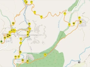
Wikiloc Trail for Alquézar & River Vero hike

Please sign in with Google to view the Wikiloc Route map.
Sign in with GoogleWeather for Alquézar & River Vero hike
Where to stay overnight near Alquézar & River Vero hike
Nearby Attractions to Alquézar & River Vero hike
 CAR
CAR
Weekend Getaway - Aragon Rivers I - Alquézar & Bierge
Weekend Getaway to the rivers of the Huesca province visiting Alquézar village & river Vero, Biege canyon& Adhuesca village for an overnight stay
Read more >
 CAR
CAR
Rivers of Aragon I - Alcanadre River & Bierge Natural Pools
10Km circular amphibious hike along the natural pools of Alcanadre River to the Bierge dam. A refreshing hike for the Summer in Aragon near to Catalan border
Read more >
 CAR
CAR